
Thank you for supporting this site ❤️
Make a donation
Make a donation
Gear up for your next adventure:
As an Amazon Associate, this site earns from qualifying purchases at no extra cost to you.
McDowell topographic map
Click on the map to display elevation.
Thank you for supporting this site ❤️
Make a donation
Make a donation
Gear up for your next adventure:
As an Amazon Associate, this site earns from qualifying purchases at no extra cost to you.
About this map
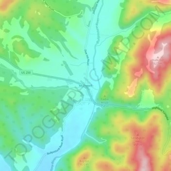
Name: McDowell topographic map, elevation, terrain.
Location: McDowell, Highland County, Virginia, 24458, United States (38.31568 -79.51060 38.35568 -79.47060)
Average elevation: 2,349 ft
Minimum elevation: 2,008 ft
Maximum elevation: 3,012 ft
Highland County trails, hiking, mountain biking, running and outdoor activities
Thank you for supporting this site ❤️
Make a donation
Make a donation
Gear up for your next adventure:
As an Amazon Associate, this site earns from qualifying purchases at no extra cost to you.