Geolocate

Rosario topographic map

Click on the map to display elevation.

About this map

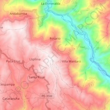
Name: Rosario topographic map, elevation, terrain.

Location: Rosario, Province of Acobamba, Huancavelica, Peru (-12.78795 -74.66290 -12.69099 -74.53908)

Average elevation: 11,375 ft

Minimum elevation: 7,598 ft

Maximum elevation: 14,019 ft

Other topographic maps

Click on a map to view its topography, its elevation and its terrain.

Caymo

Peru > Huancavelica > Salcabamba

Average elevation: 10,233 ft

Palermo

Peru > Huancavelica > El Carmen

Average elevation: 12,165 ft

Los Andes

Peru > Huancavelica

Average elevation: 13,684 ft

Yanacocha

Peru > Huancavelica

Average elevation: 11,378 ft

Gear up for your next adventure:

🔥Plasma Lighters - Windproof lighters that work in any weather condition
🥾Women's Hiking Boots - Top-rated trail boots with ankle support and superior grip
Backpacking Tents - Weight-optimized shelters for multi-day topographic surveys
📖Nature Tracking Books - Learn to track wildlife and terrain
Backpacking Tent - Lightweight and durable tent for multi‑day hikes

As an Amazon Associate, this site earns from qualifying purchases at no extra cost to you.