
Make a donation
Gear up for your next adventure:
As an Amazon Associate, this site earns from qualifying purchases at no extra cost to you.
Asén topographic map
Click on the map to display elevation.
Make a donation
Gear up for your next adventure:
As an Amazon Associate, this site earns from qualifying purchases at no extra cost to you.
About this map
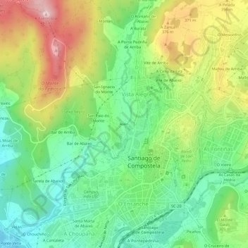
Name: Asén topographic map, elevation, terrain.
Average elevation: 909 ft
Minimum elevation: 495 ft
Maximum elevation: 1,558 ft
Make a donation
Gear up for your next adventure:
As an Amazon Associate, this site earns from qualifying purchases at no extra cost to you.
Other topographic maps
Click on a map to view its topography, its elevation and its terrain.
Make a donation
Gear up for your next adventure:
As an Amazon Associate, this site earns from qualifying purchases at no extra cost to you.
O Campón do Milladoiro
España > Galicia > Santiago > Santiago de Compostela > As Moas de Arriba
Average elevation: 791 ft
Santiago de Compostela
España > Galicia > Santiago > Santiago de Compostela
El relieve del municipio se caracteriza por una sucesión de montes entre los valles de los ríos Sar y Sarela. Además, el río Tambre hace de límite septentrional del territorio. La altitud oscila entre los 530 m (monte Espiñeira) y los 70 m a orillas del Sar. La ciudad se alza a 258 m sobre el nivel del mar.
Average elevation: 853 ft
Make a donation
Gear up for your next adventure:
As an Amazon Associate, this site earns from qualifying purchases at no extra cost to you.