Geolocate

Timonium topographic map

Click on the map to display elevation.

About this map

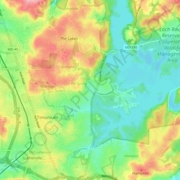
Name: Timonium topographic map, elevation, terrain.

Location: Timonium, Baltimore County, Maryland, United States (39.42849 -76.64629 39.46629 -76.55652)

Average elevation: 371 ft

Minimum elevation: 220 ft

Maximum elevation: 600 ft

Baltimore County trails, hiking, mountain biking, running and outdoor activities

Gear up for your next adventure:

📦Gear Storage Bags - Organize and protect outdoor equipment
🕶️GPS Smartphone Mount - Secure mount for phone navigation
🎒Hydration Pack - Hands‑free water reservoir for long hikes
🛌Ultralight Sleeping Bags - Compact down bags for cold nights in the wilderness
🥾Hiking Shoes - Durable and comfortable shoes for trail hiking

As an Amazon Associate, this site earns from qualifying purchases at no extra cost to you.