Geolocate

Chickamauga topographic map

Click on the map to display elevation.

About this map

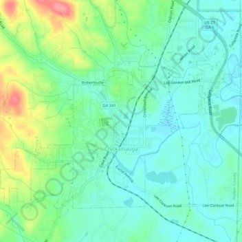
Name: Chickamauga topographic map, elevation, terrain.

Location: Chickamauga, Walker County, Georgia, United States (34.86056 -85.31627 34.89152 -85.26424)

Average elevation: 781 ft

Minimum elevation: 696 ft

Maximum elevation: 994 ft

Walker County trails, hiking, mountain biking, running and outdoor activities

Other topographic maps

Click on a map to view its topography, its elevation and its terrain.

Catlett

United States > Georgia > Walker County

Average elevation: 942 ft

Villanow

United States > Georgia > Walker County

Average elevation: 925 ft

Blowing Spring

United States > Georgia > Walker County

Average elevation: 1,063 ft

White Oak

United States > Georgia > Walker County

Average elevation: 817 ft

Gear up for your next adventure:

🪶Compact Camp Shovel - Folding shovel for campsite tasks
🧭Orienteering Set - Complete compass and map reading kit
📶Satellite Messenger - Communication device off‑grid
🧷Carabiner Set - Durable clips for gear attachment
🪶Paracord Bracelet - Survival bracelet with built‑in tools

As an Amazon Associate, this site earns from qualifying purchases at no extra cost to you.