
Meppershall topographic map
Click on the map to display elevation.
About this map
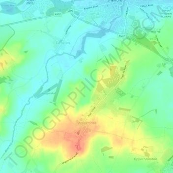
Name: Meppershall topographic map, elevation, terrain.
Location: Meppershall, Central Bedfordshire, England, United Kingdom (52.00803 -0.37011 52.03195 -0.31045)
Average elevation: 190 ft
Minimum elevation: 128 ft
Maximum elevation: 302 ft
Other topographic maps
Click on a map to view its topography, its elevation and its terrain.
Little Billington
United Kingdom > England > Central Bedfordshire > Great Billington > Little Billington
Average elevation: 302 ft
Redlodge Plantation
United Kingdom > England > Central Bedfordshire > Woburn
Average elevation: 400 ft