Geolocate

Hure Banner topographic map

Click on the map to display elevation.

About this map

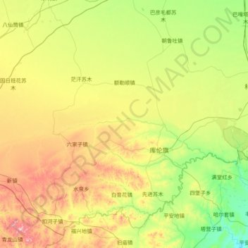
Name: Hure Banner topographic map, elevation, terrain.

Location: Hure Banner, Tongliao City, Inner Mongolia, China (42.35959 121.12865 43.30280 122.20430)

Average elevation: 974 ft

Minimum elevation: 318 ft

Maximum elevation: 2,546 ft

Other topographic maps

Click on a map to view its topography, its elevation and its terrain.

Tabunger Gaqaa

China > Inner Mongolia > Tongliao City

Average elevation: 906 ft

Mans

China > Inner Mongolia > Tongliao City

Average elevation: 1,217 ft

Laohudong

China > Inner Mongolia > Tongliao City

Average elevation: 860 ft

Gear up for your next adventure:

🦶Hiking Gaiters - Keep debris and water out of your boots
🦺Reflective Outdoor Gear - Safety gear for low‑light conditions
🛰️Handheld GPS Units - Professional satellite navigators for precise backcountry mapping
🩳Quick‑Dry Hiking Shorts - Comfortable and quick‑dry shorts for summer hiking
🔭Telescopic Hiking Pole - Adjustable pole for hiking stability

As an Amazon Associate, this site earns from qualifying purchases at no extra cost to you.