
Make a donation
Gear up for your next adventure:
As an Amazon Associate, this site earns from qualifying purchases at no extra cost to you.
Ida topographic map
Click on the map to display elevation.
Make a donation
Gear up for your next adventure:
As an Amazon Associate, this site earns from qualifying purchases at no extra cost to you.
Ida
The summit is windswept and bare with a relatively low tree line due to exposure, but the slopes of this mountain, at the edge of mild Mediterranean and colder central Anatolian climate zones, hold a wealth of endemic flora, marooned here after the Ice Age. The climate at lower altitudes has become increasingly hot and dry in the deforested landscape. The dry period lasts from May to October. Rainfall averages between 631 and 733 mm per year. The mean annual temperature is 15.7 degrees Celsius, with diurnal temperatures as high as 43.7 degrees Celsius in Edremit. The forests on the upper slopes consist mainly of Trojan fir (Abies nordmanniana subsp. equi-trojani; considered by some botanists to be a distinct species Abies equi-trojani). Deer, wild boar and jackal are common at the area. Wolves, lynx, brown bears and big cats once roamed there, but now disappeared from the mountains due to overhunting.
Make a donation
Gear up for your next adventure:
As an Amazon Associate, this site earns from qualifying purchases at no extra cost to you.
About this map
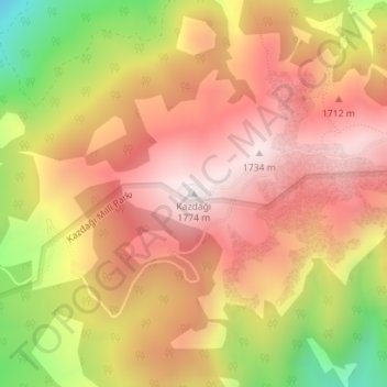
Name: Ida topographic map, elevation, terrain.
Location: Ida, Edremit, Balıkesir, Marmara Region, Turkey (39.70436 26.82914 39.70446 26.82924)
Average elevation: 4,780 ft
Minimum elevation: 3,245 ft
Maximum elevation: 5,748 ft
Make a donation
Gear up for your next adventure:
As an Amazon Associate, this site earns from qualifying purchases at no extra cost to you.