Geolocate

Seva topographic map

Click on the map to display elevation.

About this map
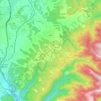
Name: Seva topographic map, elevation, terrain.

Location: Seva, Osona, Barcelona, Catalonia, 08554, Spain (41.78163 2.23181 41.86437 2.34741)

Average elevation: 2,375 ft

Minimum elevation: 1,401 ft

Maximum elevation: 4,140 ft

Other topographic maps

Click on a map to view its topography, its elevation and its terrain.
Pla de la Calma

Spain > Catalonia > Osona > el Brull

Average elevation: 3,645 ft

Gear up for your next adventure:

🛰️Satellite Messengers - Emergency SOS and two-way messaging for off-grid adventures
🎒Trekking Poles - Sturdy poles for balance and stability on rough terrain
🧥Waterproof Jacket for Hiking - Breathable and rugged rain jacket for outdoor excursions
🔦Powerful Headlamps - Ultra-bright hands-free lighting for night navigation
🦟Ultrasonic Repellers - Create a bug-free zone at your camp or rest stop

As an Amazon Associate, this site earns from qualifying purchases at no extra cost to you.