
Make a donation
Gear up for your next adventure:
As an Amazon Associate, this site earns from qualifying purchases at no extra cost to you.
Prinskouter topographic map
Click on the map to display elevation.
Make a donation
Gear up for your next adventure:
As an Amazon Associate, this site earns from qualifying purchases at no extra cost to you.
About this map
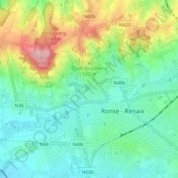
Name: Prinskouter topographic map, elevation, terrain.
Average elevation: 197 ft
Minimum elevation: 59 ft
Maximum elevation: 505 ft
Make a donation
Gear up for your next adventure:
As an Amazon Associate, this site earns from qualifying purchases at no extra cost to you.
Other topographic maps
Click on a map to view its topography, its elevation and its terrain.
Ronse
België > Oost-Vlaanderen > Oudenaarde > Ronse
Ronse is gelegen in het Zuid-Vlaamse Heuvelland of de Vlaamse Ardennen, een opvallende heuvelachtige streek in het zuiden van de provincie Oost-Vlaanderen met variërende hoogtes tussen 88 en 150 meter. Deze landschappelijke streek, die doorloopt in het Henegouwse Pays des Collines en grosso modo gesitueerd is…
Average elevation: 200 ft