
Stiefenhofen topographic map
Interactive map
Click on the map to display elevation.
About this map
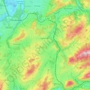
Name: Stiefenhofen topographic map, elevation, terrain.
Average elevation: 2,687 ft
Minimum elevation: 2,100 ft
Maximum elevation: 3,625 ft
Other topographic maps
Click on a map to view its topography, its elevation and its terrain.
Scheidegg
Deutschland > Bayern > Landkreis Lindau
Scheidegg, Weiler-Simmerberg, Landkreis Lindau, Bayern, 88175, Deutschland
Average elevation: 2,454 ft
Egghalden
Deutschland > Bayern > Landkreis Lindau > Zeisertsweiler
Egghalden, Zeisertsweiler, Sigmarszell, Sigmarszell (VGem), Landkreis Lindau, Bayern, 88138, Deutschland
Average elevation: 1,578 ft
Rickenbach
Deutschland > Bayern > Landkreis Lindau > Lindau (Bodensee)
Rickenbach, Lindau (Bodensee), Landkreis Lindau, Bayern, 88131, Deutschland
Average elevation: 1,404 ft