
Scheidegg topographic map
Click on the map to display elevation.
Scheidegg
Naturräumlich liegt die Gemeinde am Hang des Pfänderstocks, der aus gefalteter Süßwassermolasse aufgebaut ist und sich vom Pfänder oberhalb von Bregenz bis über Lindenberg hinaus von Westsüdwest nach Ostnordost zieht. Das Gemeindegebiet befindet sich in einem Höhenbereich von 600 bis 1000 m ü. NHN.
About this map
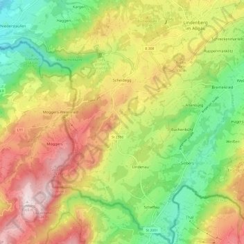
Name: Scheidegg topographic map, elevation, terrain.
Location: Scheidegg, Landkreis Lindau, Bayern, 88175, Deutschland (47.52854 9.81507 47.60993 9.88924)
Average elevation: 2,454 ft
Minimum elevation: 1,568 ft
Maximum elevation: 3,510 ft
Other topographic maps
Click on a map to view its topography, its elevation and its terrain.
Dürren
Deutschland > Bayern > Landkreis Lindau > Lindau (Bodensee) > Oberreitnau
Stadtteile: Aeschach | Bad Schachen | Degelstein | Hochbuch | Hoyren | Insel | Oberreutin | Reutin | Rickenbach | Schönau | Wannental | Zech Pfarrdörfer: Oberreitnau | Unterreitnau Dörfer: Bechtersweiler | Eggatsweiler | Heimesreutin | Höhenreute | Hörbolz | Motzach | Niederhaus | Oberhochsteg |…
Average elevation: 1,581 ft
Hörbolz
Deutschland > Bayern > Landkreis Lindau > Lindau (Bodensee)
Stadtteile: Aeschach | Bad Schachen | Degelstein | Hochbuch | Hoyren | Insel | Oberreutin | Reutin | Rickenbach | Schönau | Wannental | Zech Pfarrdörfer: Oberreitnau | Unterreitnau Dörfer: Bechtersweiler | Eggatsweiler | Heimesreutin | Höhenreute | Hörbolz | Motzach | Niederhaus | Oberhochsteg |…
Average elevation: 1,572 ft
Weiler im Allgäu
Deutschland > Bayern > Landkreis Lindau > Weiler im Allgäu
Average elevation: 2,280 ft
Oberreutin
Deutschland > Bayern > Landkreis Lindau > Lindau (Bodensee)
Stadtteile: Aeschach | Bad Schachen | Degelstein | Hochbuch | Hoyren | Insel | Oberreutin | Reutin | Rickenbach | Schönau | Wannental | Zech Pfarrdörfer: Oberreitnau | Unterreitnau Dörfer: Bechtersweiler | Eggatsweiler | Heimesreutin | Höhenreute | Hörbolz | Motzach | Niederhaus | Oberhochsteg |…
Average elevation: 1,421 ft
Rentershofen
Deutschland > Bayern > Landkreis Lindau > Röthenbach (Allgäu) > Oberhäuser
Average elevation: 2,313 ft
Obere Weberei
Deutschland > Bayern > Landkreis Lindau > Weiler-Simmerberg > Weiler im Allgäu
Average elevation: 2,283 ft
Höhenreute
Deutschland > Bayern > Landkreis Lindau > Lindau (Bodensee)
Höhenreute (mundartlich: Heritə) ist ein Gemeindeteil der bayerisch-schwäbischen Großen Kreisstadt Lindau (Bodensee).
Average elevation: 1,614 ft
Wannental
Deutschland > Bayern > Landkreis Lindau > Lindau (Bodensee)
Stadtteile: Aeschach | Bad Schachen | Degelstein | Hochbuch | Hoyren | Insel | Oberreutin | Reutin | Rickenbach | Schönau | Wannental | Zech Pfarrdörfer: Oberreitnau | Unterreitnau Dörfer: Bechtersweiler | Eggatsweiler | Heimesreutin | Höhenreute | Hörbolz | Motzach | Niederhaus | Oberhochsteg |…
Average elevation: 1,414 ft
Ruppenmanklitz
Deutschland > Bayern > Landkreis Lindau > Weiler-Simmerberg
Average elevation: 2,352 ft
Unterried
Deutschland > Bayern > Landkreis Lindau > Heimenkirch
Der Ortsname stammt vom mittelhochdeutschen Wort riet, das Ried, Sumpfgebiet oder ausgereuteter Grund (Rodung) bedeuten kann. Somit bedeutet der Ortsname (Siedlung im/beim) Ried, Sumpfgebiet oder Rodesiedlung. Der Präfix Unter- dient zur Unterscheidung zum höher gelegenen Oberried.
Average elevation: 2,149 ft
Schreckenmanklitz
Deutschland > Bayern > Landkreis Lindau > Weiler-Simmerberg
Average elevation: 2,352 ft
Steig
Deutschland > Bayern > Landkreis Lindau > Grünenbach
Der Ortsname stammt vom mittelhochdeutschen Wort steig(e) für steile Straße bzw. Anhöhe ab.
Average elevation: 2,769 ft
Biesenberg
Deutschland > Bayern > Landkreis Lindau > Meckatz
Der Ortsname setzt sich aus dem Personennamen Buoso und dem Grundwort -berg zusammen. Somit bedeutet der Ortsname (Siedlung an der) Anhöhe des Buoso.
Average elevation: 2,208 ft
Engenberg
Deutschland > Bayern > Landkreis Lindau > Meckatz
Der Ortsname stammt vom Personen(kurz)namen Enge oder Ëmmo und bedeutet somit (Siedlung an) der Anhöhe des Enge/Ëmmo.
Average elevation: 2,316 ft
BSB-Hafen Lindau (Bodensee)
Deutschland > Bayern > Landkreis Lindau > Lindau (Bodensee)
Average elevation: 1,296 ft
Bechtersweiler
Deutschland > Bayern > Landkreis Lindau > Lindau (Bodensee) > Unterreitnau > Bechtersweiler
Average elevation: 1,545 ft
Rickatshofen
Deutschland > Bayern > Landkreis Lindau > Lindau (Bodensee) > Unterreitnau
Average elevation: 1,503 ft