
Make a donation
Gear up for your next adventure:
As an Amazon Associate, this site earns from qualifying purchases at no extra cost to you.
Steinbach topographic map
Click on the map to display elevation.
Make a donation
Gear up for your next adventure:
As an Amazon Associate, this site earns from qualifying purchases at no extra cost to you.
Steinbach
Stadtmitte | Nördliche Kernstadt | Kreuzäcker | Südliche Kernstadt | Tullauer Höhe / Hagenbach | Rollhof / Reifenhof | Stadtheide | Heimbachsiedlung / Teurershof | Steinbach | Hessental | Bibersfeld | Gailenkirchen | Gelbingen | Eltershofen | Sulzdorf | Tüngental | Weckrieden
Make a donation
Gear up for your next adventure:
As an Amazon Associate, this site earns from qualifying purchases at no extra cost to you.
About this map
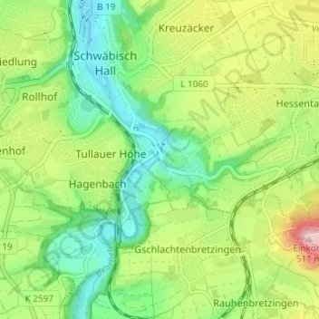
Name: Steinbach topographic map, elevation, terrain.
Average elevation: 1,188 ft
Minimum elevation: 899 ft
Maximum elevation: 1,677 ft
Make a donation
Gear up for your next adventure:
As an Amazon Associate, this site earns from qualifying purchases at no extra cost to you.
Other topographic maps
Click on a map to view its topography, its elevation and its terrain.
Gelbingen
Deutschland > Baden-Württemberg > Landkreis Schwäbisch Hall > Schwäbisch Hall
Average elevation: 1,138 ft
Gailenkirchen
Deutschland > Baden-Württemberg > Landkreis Schwäbisch Hall > Schwäbisch Hall
Average elevation: 1,306 ft
Tüngental
Deutschland > Baden-Württemberg > Landkreis Schwäbisch Hall > Schwäbisch Hall
Average elevation: 1,283 ft
74523
Deutschland > Baden-Württemberg > Landkreis Schwäbisch Hall > Schwäbisch Hall > Hessental
Average elevation: 1,329 ft
Make a donation
Gear up for your next adventure:
As an Amazon Associate, this site earns from qualifying purchases at no extra cost to you.
74523
Deutschland > Baden-Württemberg > Landkreis Schwäbisch Hall > Schwäbisch Hall > Hessental
Average elevation: 1,329 ft