
Kampar topographic map
Interactive map
Click on the map to display elevation.
About this map
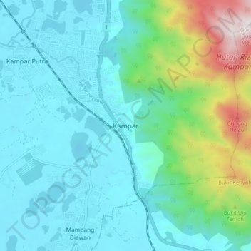
Name: Kampar topographic map, elevation, terrain.
Location: Kampar, Perak, 31900, Malaysia (4.26066 101.12145 4.34066 101.20145)
Average elevation: 787 ft
Minimum elevation: 10 ft
Maximum elevation: 4,012 ft
Other topographic maps
Click on a map to view its topography, its elevation and its terrain.
Pantai Ban Pecah
Malaysia > Perak > Kuala Kurau
Pantai Ban Pecah, Jalan Pantai, Kuala Kurau, Kerian, Perak, 34350, Malaysia
Average elevation: 7 ft
Gunung Keledang
Gunung Keledang, Ipoh, Kinta, Perak, Malaysia
Average elevation: 1,476 ft