
Make a donation
Gear up for your next adventure:
As an Amazon Associate, this site earns from qualifying purchases at no extra cost to you.
Fürstenzell topographic map
Click on the map to display elevation.
Make a donation
Gear up for your next adventure:
As an Amazon Associate, this site earns from qualifying purchases at no extra cost to you.
Fürstenzell
Im Rahmen der Gebietsreform wurden am 1. Januar 1972 die Gemeinden Altenmarkt und Bad Höhenstadt sowie Teile der Gemeinde Engertsham eingegliedert. Im Jahre 1978 folgten der größte Teil der Gemeinde Voglarn und Teile der Gemeinde Sandbach.
Make a donation
Gear up for your next adventure:
As an Amazon Associate, this site earns from qualifying purchases at no extra cost to you.
About this map
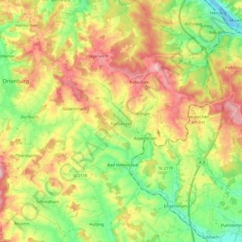
Name: Fürstenzell topographic map, elevation, terrain.
Location: Fürstenzell, Landkreis Passau, Bayern, 94081, Deutschland (48.45727 13.25518 48.59148 13.38728)
Average elevation: 1,276 ft
Minimum elevation: 965 ft
Maximum elevation: 1,660 ft
Make a donation
Gear up for your next adventure:
As an Amazon Associate, this site earns from qualifying purchases at no extra cost to you.
Other topographic maps
Click on a map to view its topography, its elevation and its terrain.
Make a donation
Gear up for your next adventure:
As an Amazon Associate, this site earns from qualifying purchases at no extra cost to you.