Geolocate

Mandeh topographic map

Click on the map to display elevation.

About this map

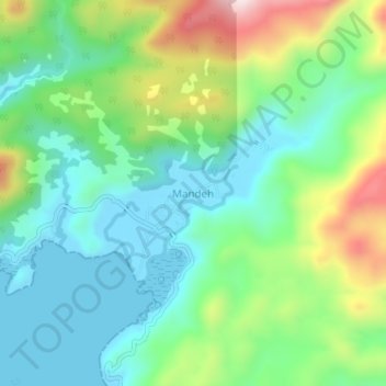
Name: Mandeh topographic map, elevation, terrain.

Location: Mandeh, Pesisir Selatan, West Sumatra, Sumatra, Indonesia (-1.21045 100.41619 -1.17045 100.45619)

Average elevation: 463 ft

Minimum elevation: -7 ft

Maximum elevation: 1,522 ft

Other topographic maps

Click on a map to view its topography, its elevation and its terrain.

Gear up for your next adventure:

📦Dry Bags Set - Waterproof storage for electronics and clothes
GPS Sports Watch - GPS watch for running, hiking and training
Backpacking Tent - Lightweight and durable tent for multi‑day hikes
🧴Hand Sanitizer - Keep hands clean while hiking
🧯Portable Fire Pit - Compact fire pit for camping spots

As an Amazon Associate, this site earns from qualifying purchases at no extra cost to you.