
Make a donation
Gear up for your next adventure:
As an Amazon Associate, this site earns from qualifying purchases at no extra cost to you.
Bachhausen topographic map
Click on the map to display elevation.
Make a donation
Gear up for your next adventure:
As an Amazon Associate, this site earns from qualifying purchases at no extra cost to you.
Bachhausen
Allmannshausen | Assenhausen | Aufhausen | Aufkirchen | Bachhausen | Berg | Biberkor | Farchach | Harkirchen | Höhenrain | Kempfenhausen | Leoni | Martinsholzen | Mörlbach | Sibichhausen
Make a donation
Gear up for your next adventure:
As an Amazon Associate, this site earns from qualifying purchases at no extra cost to you.
About this map
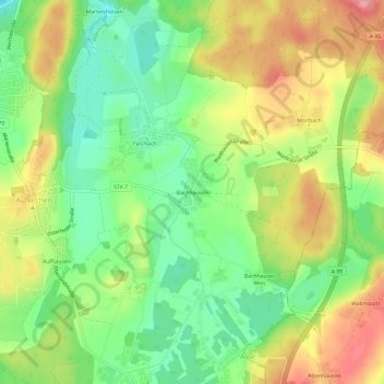
Name: Bachhausen topographic map, elevation, terrain.
Average elevation: 2,146 ft
Minimum elevation: 1,985 ft
Maximum elevation: 2,339 ft
Make a donation
Gear up for your next adventure:
As an Amazon Associate, this site earns from qualifying purchases at no extra cost to you.
Other topographic maps
Click on a map to view its topography, its elevation and its terrain.
Berg
Deutschland > Bayern > Landkreis Starnberg > Berg
Es gibt die Gemarkungen Bachhausen, Berg, Höhenrain, Kempfenhausen und Wadlhauser Gräben.
Average elevation: 2,067 ft