
Durango topographic map
Click on the map to display elevation.
Durango
Durango is located at 37°16′N 107°52′W / 37.267°N 107.867°W / 37.267; -107.867 at an elevation of 6,512 ft (1,988 m). At the 2020 United States Census, the town had a total area of 10,946 acres (44.296 km2) including 1,533 acres (6.203 km2) of water.
About this map
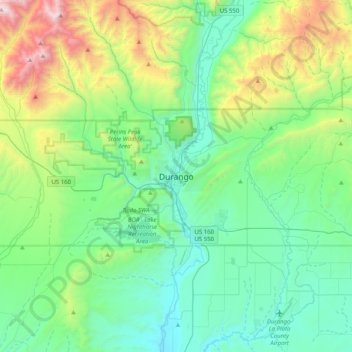
Name: Durango topographic map, elevation, terrain.
Location: Durango, La Plata County, Colorado, 81302, United States (37.11695 -108.03660 37.43695 -107.71660)
Average elevation: 7,743 ft
Minimum elevation: 6,142 ft
Maximum elevation: 12,946 ft
La Plata County trails, hiking, mountain biking, running and outdoor activities