
Scobey topographic map
Interactive map
Click on the map to display elevation.
About this map
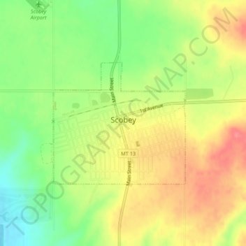
Name: Scobey topographic map, elevation, terrain.
Location: Scobey, Daniels County, Montana, 59263, United States (48.78499 -105.43161 48.79838 -105.40957)
Average elevation: 2,461 ft
Minimum elevation: 2,326 ft
Maximum elevation: 2,585 ft
Other topographic maps
Click on a map to view its topography, its elevation and its terrain.
Madoc
United States > Montana > Daniels County
Madoc, Daniels County, Montana, United States
Average elevation: 2,769 ft
Flaxville
United States > Montana > Daniels County
Flaxville, Daniels County, Montana, United States
Average elevation: 2,766 ft
Whitetail
United States > Montana > Daniels County > Whitetail
Whitetail, Daniels County, Montana, 59276, United States
Average elevation: 2,569 ft
Butte Creek
United States > Montana > Daniels County > Butte Creek
Butte Creek, Daniels County, Montana, United States
Average elevation: 2,690 ft