
Make a donation
Gear up for your next adventure:
As an Amazon Associate, this site earns from qualifying purchases at no extra cost to you.
São Luís topographic map
Click on the map to display elevation.
Make a donation
Gear up for your next adventure:
As an Amazon Associate, this site earns from qualifying purchases at no extra cost to you.
About this map
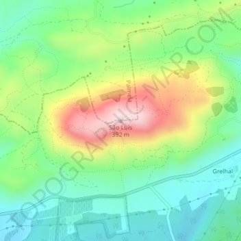
Name: São Luís topographic map, elevation, terrain.
Location: São Luís, Setúbal, 2951-901, Portugal (38.53345 -8.93870 38.53355 -8.93860)
Average elevation: 522 ft
Minimum elevation: 118 ft
Maximum elevation: 1,250 ft
Make a donation
Gear up for your next adventure:
As an Amazon Associate, this site earns from qualifying purchases at no extra cost to you.
Other topographic maps
Click on a map to view its topography, its elevation and its terrain.
Palácio e Quinta da Bacalhoa
Portugal > Setúbal > Setúbal > Vila Fresca de Azeitão
Average elevation: 400 ft
Make a donation
Gear up for your next adventure:
As an Amazon Associate, this site earns from qualifying purchases at no extra cost to you.