Make a donation
Gear up for your next adventure:
As an Amazon Associate, this site earns from qualifying purchases at no extra cost to you.
Cleveland topographic map
Click on the map to display elevation.
Make a donation
Gear up for your next adventure:
As an Amazon Associate, this site earns from qualifying purchases at no extra cost to you.
About this map
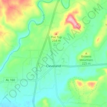
Name: Cleveland topographic map, elevation, terrain.
Location: Cleveland, Blount County, Alabama, United States (33.97099 -86.59656 34.02287 -86.54944)
Average elevation: 594 ft
Minimum elevation: 443 ft
Maximum elevation: 948 ft
Blount County trails, hiking, mountain biking, running and outdoor activities
Make a donation
Gear up for your next adventure:
As an Amazon Associate, this site earns from qualifying purchases at no extra cost to you.
Other topographic maps
Click on a map to view its topography, its elevation and its terrain.
Make a donation
Gear up for your next adventure:
As an Amazon Associate, this site earns from qualifying purchases at no extra cost to you.
Make a donation
Gear up for your next adventure:
As an Amazon Associate, this site earns from qualifying purchases at no extra cost to you.
Highland Lake
United States > Alabama > Blount County
Highland Lake is located in eastern Blount County at 33°53'3.376" North, 86°25'19.744" West (33.884271, -86.422151). The town consists of homes built around Highland Lake, a reservoir on the Blackburn Fork of the Little Warrior River. The lake, at an elevation of 895 feet (273 m) above sea level, is in a…
Average elevation: 981 ft
Make a donation
Gear up for your next adventure:
As an Amazon Associate, this site earns from qualifying purchases at no extra cost to you.
Make a donation
Gear up for your next adventure:
As an Amazon Associate, this site earns from qualifying purchases at no extra cost to you.
