
Thank you for supporting this site ❤️
Make a donation
Make a donation
Gear up for your next adventure:
As an Amazon Associate, this site earns from qualifying purchases at no extra cost to you.
Ibiúna topographic map
Click on the map to display elevation.
Thank you for supporting this site ❤️
Make a donation
Make a donation
Gear up for your next adventure:
As an Amazon Associate, this site earns from qualifying purchases at no extra cost to you.
Ibiúna
Ibiúna is a municipality in the state of São Paulo in Brazil. It is part of the Metropolitan Region of Sorocaba.[2] The population is 79,479 (2020 est.) in an area of 1058.08 km2.[3] The elevation is 860 m.
Thank you for supporting this site ❤️
Make a donation
Make a donation
Gear up for your next adventure:
As an Amazon Associate, this site earns from qualifying purchases at no extra cost to you.
About this map
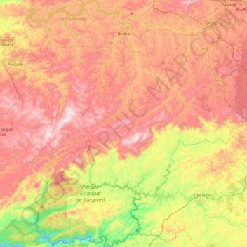
Name: Ibiúna topographic map, elevation, terrain.
Average elevation: 2,756 ft
Minimum elevation: 1,335 ft
Maximum elevation: 3,934 ft
Thank you for supporting this site ❤️
Make a donation
Make a donation
Gear up for your next adventure:
As an Amazon Associate, this site earns from qualifying purchases at no extra cost to you.