Geolocate

Schwanham topographic map

Interactive map

Click on the map to display elevation.

About this map

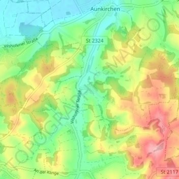
Name: Schwanham topographic map, elevation, terrain.

Location: Schwanham, Vilshofen an der Donau, Landkreis Passau, Bayern, 94501, Deutschland (48.56067 13.10526 48.60067 13.14526)

Average elevation: 1,211 ft

Minimum elevation: 1,027 ft

Maximum elevation: 1,476 ft

Other topographic maps

Click on a map to view its topography, its elevation and its terrain.

Zeitlarn

Deutschland > Bayern > Landkreis Passau > Vilshofen an der Donau

Zeitlarn, Vilshofen an der Donau, Landkreis Passau, Bayern, 94474, Deutschland

Average elevation: 1,158 ft

Sollasöd

Deutschland > Bayern > Landkreis Passau > Vilshofen an der Donau > Lindach

Sollasöd, Lindach, Vilshofen an der Donau, Landkreis Passau, Bayern, 94474, Deutschland

Average elevation: 1,175 ft

Reut

Deutschland > Bayern > Landkreis Passau > Vilshofen an der Donau > Aunkirchen

Reut, Aunkirchen, Vilshofen an der Donau, Landkreis Passau, Bayern, 94501, Deutschland

Average elevation: 1,155 ft

Schönerting

Deutschland > Bayern > Landkreis Passau > Vilshofen an der Donau > Schönerting

Schönerting, Vilshofen an der Donau, Landkreis Passau, Bayern, 94501, Deutschland

Average elevation: 1,122 ft

Pleinting

Deutschland > Bayern > Landkreis Passau > Vilshofen an der Donau

Pleinting, Vilshofen an der Donau, Landkreis Passau, Bayern, 94544, Deutschland

Average elevation: 1,096 ft