
Make a donation
Gear up for your next adventure:
As an Amazon Associate, this site earns from qualifying purchases at no extra cost to you.
Pocono Township topographic map
Click on the map to display elevation.
Make a donation
Gear up for your next adventure:
As an Amazon Associate, this site earns from qualifying purchases at no extra cost to you.
About this map
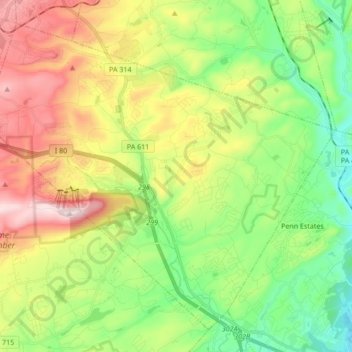
Name: Pocono Township topographic map, elevation, terrain.
Location: Pocono Township, Monroe County, Pennsylvania, United States (40.99978 -75.39357 41.11146 -75.22355)
Average elevation: 1,102 ft
Minimum elevation: 469 ft
Maximum elevation: 2,093 ft
Monroe County trails, hiking, mountain biking, running and outdoor activities
Make a donation
Gear up for your next adventure:
As an Amazon Associate, this site earns from qualifying purchases at no extra cost to you.
Other topographic maps
Click on a map to view its topography, its elevation and its terrain.
Otter Lake
United States > Pennsylvania > Monroe County > Middle Smithfield Township
Average elevation: 1,158 ft
Camelback Mountain
United States > Pennsylvania > Monroe County > Jackson Township
Average elevation: 1,503 ft
Kalahari Indoor Waterpark
United States > Pennsylvania > Monroe County > Tobyhanna Township
Average elevation: 1,814 ft
Make a donation
Gear up for your next adventure:
As an Amazon Associate, this site earns from qualifying purchases at no extra cost to you.
Great Wolf Lodge Water Park
United States > Pennsylvania > Monroe County > Pocono Township > Scotrun
Average elevation: 1,161 ft
Buck Hill Falls
United States > Pennsylvania > Monroe County > Barrett Township > Mountainhome
Average elevation: 1,247 ft
Camelot Forest
United States > Pennsylvania > Monroe County > Tobyhanna Township
Average elevation: 1,686 ft
Make a donation
Gear up for your next adventure:
As an Amazon Associate, this site earns from qualifying purchases at no extra cost to you.
Pinecrest Lake
United States > Pennsylvania > Monroe County > Tobyhanna Township
Average elevation: 1,824 ft