
Make a donation
Gear up for your next adventure:
As an Amazon Associate, this site earns from qualifying purchases at no extra cost to you.
El Espinillo topographic map
Click on the map to display elevation.
Make a donation
Gear up for your next adventure:
As an Amazon Associate, this site earns from qualifying purchases at no extra cost to you.
About this map
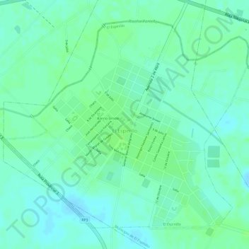
Name: El Espinillo topographic map, elevation, terrain.
Average elevation: 279 ft
Minimum elevation: 259 ft
Maximum elevation: 292 ft
Make a donation
Gear up for your next adventure:
As an Amazon Associate, this site earns from qualifying purchases at no extra cost to you.
Other topographic maps
Click on a map to view its topography, its elevation and its terrain.
Municipio de Formosa
Se ubica en una extensa llanura, a una altitud de 57 m s. n. m., en una barranca pronunciada sobre el río Paraguay. En las cercanías se desarrollan lagunas, bañados y riachos. La laguna más importante es la Oca, antiguo curso del río Paraguay declarada en 2001 Reserva de la biosfera.
Average elevation: 197 ft
Make a donation
Gear up for your next adventure:
As an Amazon Associate, this site earns from qualifying purchases at no extra cost to you.
Make a donation
Gear up for your next adventure:
As an Amazon Associate, this site earns from qualifying purchases at no extra cost to you.
Make a donation
Gear up for your next adventure:
As an Amazon Associate, this site earns from qualifying purchases at no extra cost to you.