Geolocate

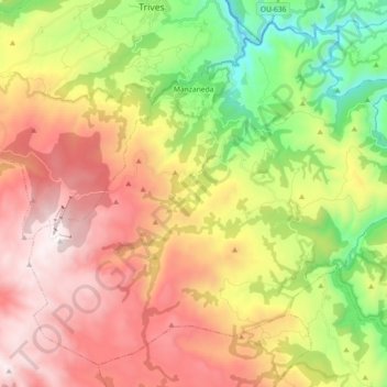
Manzaneda topographic map

Click on the map to display elevation.

Manzaneda

Destaca el pico Cabeza de Manzaneda, uno de los puntos más altos de Galicia con sus 1778 m de altitud.

Wikipedia (CC-BY-SA 3.0)

About this map

Name: Manzaneda topographic map, elevation, terrain.

Location: Manzaneda, Terra de Trives, Ourense, Galicia, España (42.21360 -7.31269 42.33286 -7.13046)

Average elevation: 3,333 ft

Minimum elevation: 984 ft

Maximum elevation: 5,817 ft

Other topographic maps

Click on a map to view its topography, its elevation and its terrain.

Trives

España > Galicia > Terra de Trives > A Pobra de Trives

Average elevation: 2,362 ft

O Campelo

España > Galicia > Terra de Trives > A Pobra de Trives

Average elevation: 1,998 ft

Fitoiro

España > Galicia > Terra de Trives

Average elevation: 3,468 ft

Gear up for your next adventure:

💧Water Purification System - Clean water on the trail with reliable purifiers
🔪Outdoor Multitools - Essential survival tools for gear repair and field use
🗺️NatGeo Topo Maps - High-quality waterproof printed topographic maps of US Parks
📶Satellite Messenger - Communication device off‑grid
👟Men's Trail Runners - Lightweight footwear for fast-paced exploration and light hiking

As an Amazon Associate, this site earns from qualifying purchases at no extra cost to you.