
Thank you for supporting this site ❤️
Make a donation
Make a donation
Gear up for your next adventure:
As an Amazon Associate, this site earns from qualifying purchases at no extra cost to you.
پنو topographic map
Click on the map to display elevation.
Thank you for supporting this site ❤️
Make a donation
Make a donation
Gear up for your next adventure:
As an Amazon Associate, this site earns from qualifying purchases at no extra cost to you.
About this map
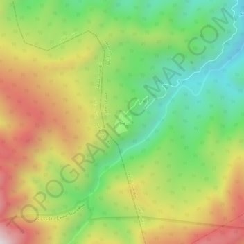
Name: پنو topographic map, elevation, terrain.
Location: پنو, بخش اطاقور, Langarud County, Gilan Province, Iran (37.02126 49.98682 37.06126 50.02682)
Average elevation: 2,156 ft
Minimum elevation: 653 ft
Maximum elevation: 4,078 ft
Thank you for supporting this site ❤️
Make a donation
Make a donation
Gear up for your next adventure:
As an Amazon Associate, this site earns from qualifying purchases at no extra cost to you.