
Bara Shigri Glacier topographic map
Interactive map
Click on the map to display elevation.
About this map
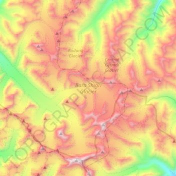
Name: Bara Shigri Glacier topographic map, elevation, terrain.
Average elevation: 17,615 ft
Minimum elevation: 13,661 ft
Maximum elevation: 21,621 ft
Other topographic maps
Click on a map to view its topography, its elevation and its terrain.
Yamling
India > Himachal Pradesh > Lahul
Yamling, Lahul, Lahaul and Spiti District, Himachal Pradesh, India
Average elevation: 11,220 ft
Rohtang Pass
India > Himachal Pradesh > Lahul
Rohtang Pass, Lahul, Lahul and Spiti, Himachal Pradesh, India
Average elevation: 13,261 ft
Baralacha Pass
India > Himachal Pradesh > Lahul
Baralacha Pass, Lahul, Lahul and Spiti, Himachal Pradesh, India
Average elevation: 16,348 ft
Sarchu
India > Himachal Pradesh > Lahul
Sarchu, Lahul, Lahul and Spiti, Himachal Pradesh, India
Average elevation: 17,743 ft
Keylang
India > Himachal Pradesh > Lahul > Keylang
Keylang, Lahul, Lahul and Spiti, Himachal Pradesh, 175132, India
Average elevation: 12,556 ft
Lahul
India > Himachal Pradesh > Lahul
Lahul, Lahul and Spiti, Himachal Pradesh, India
Average elevation: 14,931 ft