Geolocate

Guilford topographic map

Click on the map to display elevation.

About this map

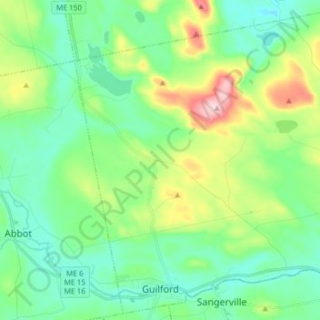
Name: Guilford topographic map, elevation, terrain.

Location: Guilford, Piscataquis County, Maine, 04443, United States (45.16091 -69.42448 45.26060 -69.27654)

Average elevation: 574 ft

Minimum elevation: 308 ft

Maximum elevation: 1,296 ft

Piscataquis County trails, hiking, mountain biking, running and outdoor activities

Other topographic maps

Click on a map to view its topography, its elevation and its terrain.

Schoodic

United States > Maine > Piscataquis County

Average elevation: 525 ft

Shirley Mills

United States > Maine > Piscataquis County > Shirley

Average elevation: 1,158 ft

Kokadjo

United States > Maine > Piscataquis County

Average elevation: 1,322 ft

Ebeemee Mountain

United States > Maine > Piscataquis County

Average elevation: 1,220 ft

Gear up for your next adventure:

🩹Survival Bandages - High‑quality bandages for emergencies
🔦Powerful Headlamps - Ultra-bright hands-free lighting for night navigation
🏫Relief Map Kits - Hands-on tools for teaching landforms and elevation
🛏️Cold Weather Sleeping Bag - Warm sleeping bag for cold conditions
📡Handheld GPS Device - Reliable handheld GPS for outdoor navigation

As an Amazon Associate, this site earns from qualifying purchases at no extra cost to you.