
Thank you for supporting this site ❤️
Make a donation
Make a donation
Gear up for your next adventure:
As an Amazon Associate, this site earns from qualifying purchases at no extra cost to you.
Rodheim-Bieber topographic map
Click on the map to display elevation.
Thank you for supporting this site ❤️
Make a donation
Make a donation
Gear up for your next adventure:
As an Amazon Associate, this site earns from qualifying purchases at no extra cost to you.
About this map
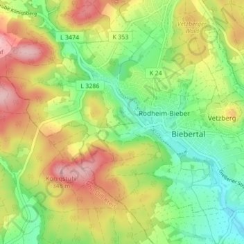
Name: Rodheim-Bieber topographic map, elevation, terrain.
Location: Rodheim-Bieber, Biebertal, Landkreis Gießen, Hesse, Germany (50.60306 8.55929 50.63521 8.62730)
Average elevation: 784 ft
Minimum elevation: 561 ft
Maximum elevation: 1,125 ft
Thank you for supporting this site ❤️
Make a donation
Make a donation
Gear up for your next adventure:
As an Amazon Associate, this site earns from qualifying purchases at no extra cost to you.
Other topographic maps
Click on a map to view its topography, its elevation and its terrain.