
Make a donation
Gear up for your next adventure:
As an Amazon Associate, this site earns from qualifying purchases at no extra cost to you.
Deuz topographic map
Click on the map to display elevation.
Make a donation
Gear up for your next adventure:
As an Amazon Associate, this site earns from qualifying purchases at no extra cost to you.
About this map
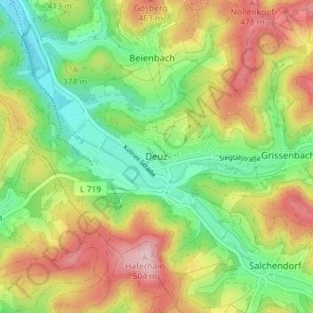
Name: Deuz topographic map, elevation, terrain.
Average elevation: 1,250 ft
Minimum elevation: 951 ft
Maximum elevation: 1,634 ft
Make a donation
Gear up for your next adventure:
As an Amazon Associate, this site earns from qualifying purchases at no extra cost to you.
Other topographic maps
Click on a map to view its topography, its elevation and its terrain.
Unglinghausen
Deutschland > Nordrhein-Westfalen > Kreis Siegen-Wittgenstein > Netphen
Average elevation: 1,217 ft
Oelgershausen
Deutschland > Nordrhein-Westfalen > Kreis Siegen-Wittgenstein > Netphen
Average elevation: 1,148 ft
Grissenbach
Deutschland > Nordrhein-Westfalen > Kreis Siegen-Wittgenstein > Netphen
Average elevation: 1,342 ft
Salchendorf
Deutschland > Nordrhein-Westfalen > Kreis Siegen-Wittgenstein > Netphen
Die Bebauung des Orts befindet sich auf einer Höhe zwischen 330 und 390 m ü. NHN. Die Gemarkung Salchendorf hat eine Fläche von 9,2 km². Berge und Erhebungen um Salchendorf sind unter anderem Heinenberg 530,7 m, Rübenhain, Auf der Noll mit 474,1 m und der Haferhain mit 503,5 m Höhe. Durch den Ort fließt…
Average elevation: 1,322 ft
Make a donation
Gear up for your next adventure:
As an Amazon Associate, this site earns from qualifying purchases at no extra cost to you.
Werthenbach
Deutschland > Nordrhein-Westfalen > Kreis Siegen-Wittgenstein > Netphen
Average elevation: 1,604 ft
Helgersdorf
Deutschland > Nordrhein-Westfalen > Kreis Siegen-Wittgenstein > Netphen
Average elevation: 1,358 ft
Nenkersdorf
Deutschland > Nordrhein-Westfalen > Kreis Siegen-Wittgenstein > Netphen > Nenkersdorf
Average elevation: 1,594 ft
Sohlbach
Deutschland > Nordrhein-Westfalen > Kreis Siegen-Wittgenstein > Netphen > Sohlbach
Average elevation: 1,611 ft
Make a donation
Gear up for your next adventure:
As an Amazon Associate, this site earns from qualifying purchases at no extra cost to you.