Geolocate

Macatunao topographic map

Click on the map to display elevation.

About this map

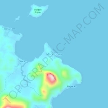
Name: Macatunao topographic map, elevation, terrain.

Location: Macatunao, Concepcion, Iloilo, Western Visayas, Philippines (11.28154 123.16324 11.32154 123.20324)

Average elevation: 72 ft

Minimum elevation: -3 ft

Maximum elevation: 1,158 ft

Other topographic maps

Click on a map to view its topography, its elevation and its terrain.

Magais Island

Philippines > Iloilo > Concepcion > Talotu-an

Average elevation: 7 ft

Chico Island

Philippines > Iloilo > Concepcion > Malangabang

Average elevation: 20 ft

Gear up for your next adventure:

🥤Water Filter Bottle - All‑in‑one filter bottle for safe hydration
🎒Gear Packing Cubes - Organize your backpack efficiently
🥾Women's Hiking Boots - Top-rated trail boots with ankle support and superior grip
📖Nature Tracking Books - Learn to track wildlife and terrain
🧢Outdoor Hiking Hat - Sun protection hat for outdoor explorers

As an Amazon Associate, this site earns from qualifying purchases at no extra cost to you.