Geolocate

Chebeague Island topographic map

Click on the map to display elevation.

About this map

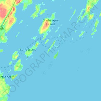
Name: Chebeague Island topographic map, elevation, terrain.

Location: Chebeague Island, Cumberland County, Maine, 04017, United States (43.59789 -70.16904 43.78097 -69.96371)

Average elevation: 13 ft

Minimum elevation: -7 ft

Maximum elevation: 220 ft

Cumberland County trails, hiking, mountain biking, running and outdoor activities

Other topographic maps

Click on a map to view its topography, its elevation and its terrain.

Brunswick

United States > Maine > Cumberland County

Average elevation: 85 ft

South Casco

United States > Maine > Cumberland County > Casco

Average elevation: 312 ft

North Bridgton

United States > Maine > Cumberland County > Bridgton

Average elevation: 400 ft

Oak Hill

United States > Maine > Cumberland County > Brunswick

Average elevation: 154 ft

USM Hedges

United States > Maine > Cumberland County > Gorham

Average elevation: 223 ft

Gear up for your next adventure:

🪓Survival Multi‑Tool - Versatile tool for camp and trail tasks
🛠️Outdoor Gear Repair Kit - Essential tools to fix gear on the trail
🚑Emergency Bivvies - Heat-reflective sleeping bags for survival situations
🗺️NatGeo Topo Maps - High-quality waterproof printed topographic maps of US Parks
📚Navigation Handbooks - Master the art of reading topographic maps and using a compass

As an Amazon Associate, this site earns from qualifying purchases at no extra cost to you.