
Make a donation
Gear up for your next adventure:
As an Amazon Associate, this site earns from qualifying purchases at no extra cost to you.
Linow topographic map
Click on the map to display elevation.
Make a donation
Gear up for your next adventure:
As an Amazon Associate, this site earns from qualifying purchases at no extra cost to you.
About this map
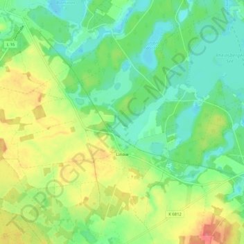
Name: Linow topographic map, elevation, terrain.
Average elevation: 243 ft
Minimum elevation: 157 ft
Maximum elevation: 384 ft
Make a donation
Gear up for your next adventure:
As an Amazon Associate, this site earns from qualifying purchases at no extra cost to you.
Other topographic maps
Click on a map to view its topography, its elevation and its terrain.
Kleiner Stechlinsee
Deutschland > Brandenburg > Ostprignitz-Ruppin > Rheinsberg > Stechlin
Average elevation: 233 ft
Kleiner Wummsee
Deutschland > Brandenburg > Ostprignitz-Ruppin > Rheinsberg > Flecken Zechlin
Average elevation: 269 ft
Großer Zechliner See
Deutschland > Brandenburg > Ostprignitz-Ruppin > Rheinsberg > Flecken Zechlin
Average elevation: 220 ft
Großer Prebelowsee
Deutschland > Brandenburg > Ostprignitz-Ruppin > Rheinsberg > Zechlinerhütte
Average elevation: 213 ft
Make a donation
Gear up for your next adventure:
As an Amazon Associate, this site earns from qualifying purchases at no extra cost to you.
Kleiner Prebelowsee
Deutschland > Brandenburg > Ostprignitz-Ruppin > Rheinsberg > Zechlinerhütte
Average elevation: 213 ft
Dorfstraße
Deutschland > Brandenburg > Ostprignitz-Ruppin > Rheinsberg > Flecken Zechlin
Average elevation: 292 ft
Make a donation
Gear up for your next adventure:
As an Amazon Associate, this site earns from qualifying purchases at no extra cost to you.