Geolocate

Centerville topographic map

Click on the map to display elevation.

About this map

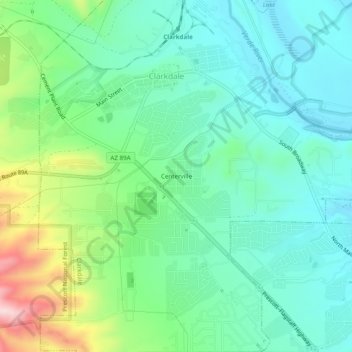
Name: Centerville topographic map, elevation, terrain.

Location: Centerville, Clarkdale, Yavapai County, Arizona, 86324, United States (34.73974 -112.07655 34.77974 -112.03655)

Average elevation: 3,619 ft

Minimum elevation: 3,320 ft

Maximum elevation: 4,439 ft

Yavapai County trails, hiking, mountain biking, running and outdoor activities

Other topographic maps

Click on a map to view its topography, its elevation and its terrain.

Gear up for your next adventure:

🌎3D Topographic Globes - Raised relief globes for a tactile understanding of geography
🛡️Bear Spray Outdoor - Protection in bear country hikes
🧯Emergency Survival Kit - All‑in‑one survival essentials for the backcountry
🧷Carabiner Set - Durable clips for gear attachment
🚗GPS Dash Cams - Record your scenic drives through mountain passes and canyons

As an Amazon Associate, this site earns from qualifying purchases at no extra cost to you.