Geolocate

Stromboli topographic map

Click on the map to display elevation.

👉 Easily get elevation data in JSON, GeoTIFF and KML formats using Elevation API
Thank you for supporting this site ❤️
Make a donation

About this map

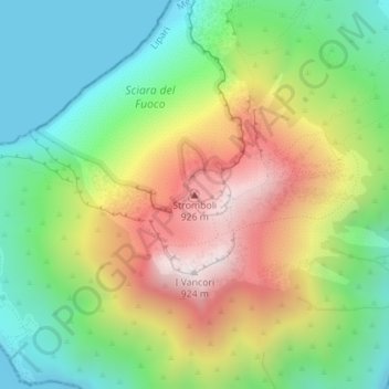
Name: Stromboli topographic map, elevation, terrain.

Location: Stromboli, Lipari, Messina, Sicily, Italy (38.79298 15.21080 38.79308 15.21090)

Average elevation: 1,220 ft

Minimum elevation: 0 ft

Maximum elevation: 2,999 ft

Other topographic maps

Click on a map to view its topography, its elevation and its terrain.

Isola di Vulcano

Italy > Sicily > Messina > Lipari

Average elevation: 249 ft

Isola di Stromboli

Italy > Sicily > Messina > Lipari

Average elevation: 525 ft

Alicudi

Italy > Sicily > Messina > Lipari

Average elevation: 505 ft

Alicudi

Italy > Sicily > Messina > Lipari

Average elevation: 505 ft

Gear up for your next adventure:

🔦LED Headlamp - Bright and durable LED headlamp for night navigation
🎒Trail Energy Bars - High‑calorie bars for hiking energy
🔦Powerful Headlamps - Ultra-bright hands-free lighting for night navigation
🦟Ultrasonic Repellers - Create a bug-free zone at your camp or rest stop
🛌Ultralight Sleeping Bags - Compact down bags for cold nights in the wilderness

As an Amazon Associate, this site earns from qualifying purchases at no extra cost to you.