Geolocate

Jukdo-dong topographic map

Interactive map

Click on the map to display elevation.

About this map

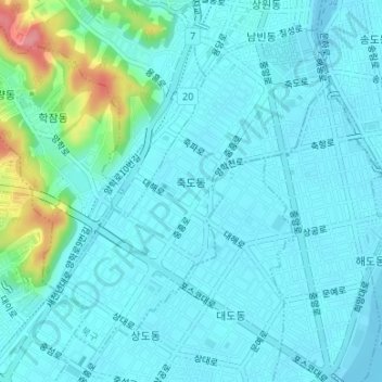
Name: Jukdo-dong topographic map, elevation, terrain.

Location: Jukdo-dong, Buk-gu, Pohang-si, North Gyeongsang, South Korea (36.01406 129.34748 36.03684 129.37129)

Average elevation: 49 ft

Minimum elevation: 0 ft

Maximum elevation: 305 ft

Other topographic maps

Click on a map to view its topography, its elevation and its terrain.

Nam-gu

South Korea > Pohang-si

Nam-gu, Pohang-si, North Gyeongsang, South Korea

Average elevation: 318 ft

Buk-gu

South Korea > Pohang-si

Buk-gu, Pohang-si, North Gyeongsang, South Korea

Average elevation: 440 ft

Jungang-dong

South Korea > Pohang-si > Jungang-dong

Jungang-dong, Buk-gu, Pohang-si, North Gyeongsang, South Korea

Average elevation: 69 ft

Daesong-myeon

South Korea > Pohang-si > Daesong-myeon

Daesong-myeon, Nam-gu, Pohang-si, Gyeongsangbuk-do, South Korea

Average elevation: 495 ft

Ocheon-eup

South Korea > Pohang-si

Ocheon-eup, Nam-gu, Pohang-si, North Gyeongsang, South Korea

Average elevation: 545 ft