
Make a donation
Gear up for your next adventure:
As an Amazon Associate, this site earns from qualifying purchases at no extra cost to you.
Parque Lomas de la Presa topographic map
Click on the map to display elevation.
Make a donation
Gear up for your next adventure:
As an Amazon Associate, this site earns from qualifying purchases at no extra cost to you.
About this map
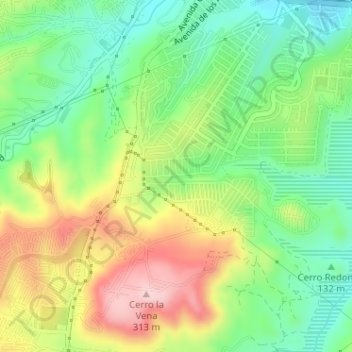
Name: Parque Lomas de la Presa topographic map, elevation, terrain.
Average elevation: 554 ft
Minimum elevation: 236 ft
Maximum elevation: 1,017 ft
Make a donation
Gear up for your next adventure:
As an Amazon Associate, this site earns from qualifying purchases at no extra cost to you.
Other topographic maps
Click on a map to view its topography, its elevation and its terrain.
Parque ITR Nuevo Leon
México > Baja California > Municipio de Tijuana > Tijuana
Average elevation: 374 ft
Reserva Natural UABC Otay
México > Baja California > Municipio de Tijuana > Tijuana
Average elevation: 449 ft
Parque Teniente Guerrero
México > Baja California > Municipio de Tijuana > Tijuana
Average elevation: 161 ft
Make a donation
Gear up for your next adventure:
As an Amazon Associate, this site earns from qualifying purchases at no extra cost to you.
EcoParque
México > Baja California > Municipio de Tijuana > Tijuana > Misiones de Pedregal Fraccionamiento
Average elevation: 295 ft
Parque Lomas de la Presa
México > Baja California > Municipio de Tijuana > Tijuana
Average elevation: 554 ft
Make a donation
Gear up for your next adventure:
As an Amazon Associate, this site earns from qualifying purchases at no extra cost to you.