
Make a donation
Gear up for your next adventure:
As an Amazon Associate, this site earns from qualifying purchases at no extra cost to you.
Haarbrücken topographic map
Click on the map to display elevation.
Make a donation
Gear up for your next adventure:
As an Amazon Associate, this site earns from qualifying purchases at no extra cost to you.
Haarbrücken
Der alte Ortskern Haarbrückens befindet sich nördlich der Röden. Die jüngeren Bebauungen aus der Mitte des 20. Jahrhunderts liegen auf den südwestlichen Höhen des Neustadter Kessels, etwa zwei Kilometer von Neustadt entfernt. Durch den Ort führt eine Gemeindestraße, die Neustadt mit Coburg verbindet.
Make a donation
Gear up for your next adventure:
As an Amazon Associate, this site earns from qualifying purchases at no extra cost to you.
About this map
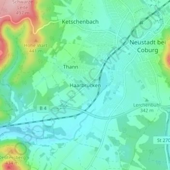
Name: Haarbrücken topographic map, elevation, terrain.
Average elevation: 1,161 ft
Minimum elevation: 1,030 ft
Maximum elevation: 1,640 ft
Make a donation
Gear up for your next adventure:
As an Amazon Associate, this site earns from qualifying purchases at no extra cost to you.
Other topographic maps
Click on a map to view its topography, its elevation and its terrain.
96465
Deutschland > Bayern > Landkreis Coburg > Neustadt bei Coburg > Haarbrücken
Average elevation: 1,220 ft