
Ringwood topographic map
Click on the map to display elevation.
About this map
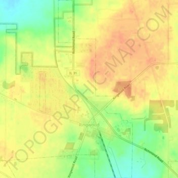
Name: Ringwood topographic map, elevation, terrain.
Location: Ringwood, McHenry County, Illinois, United States (42.38216 -88.32243 42.41561 -88.28599)
Average elevation: 863 ft
Minimum elevation: 778 ft
Maximum elevation: 912 ft
McHenry County trails, hiking, mountain biking, running and outdoor activities
Other topographic maps
Click on a map to view its topography, its elevation and its terrain.
Elizabeth Lake Nature Preserve
United States > Illinois > McHenry County > Twin Lakes
Average elevation: 820 ft