Geolocate

Landmarks topographic map

Click on the map to display elevation.

About this map

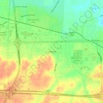
Name: Landmarks topographic map, elevation, terrain.

Location: Landmarks, Montgomery, Montgomery County, Alabama, 36119, United States (32.35847 -86.21441 32.39847 -86.17441)

Average elevation: 236 ft

Minimum elevation: 161 ft

Maximum elevation: 302 ft

Other topographic maps

Click on a map to view its topography, its elevation and its terrain.

Fain Park

United States > Alabama > Montgomery County > Montgomery

Average elevation: 230 ft

Gear up for your next adventure:

🗻Climbing Gear Basics - Essential gear for beginner climbers
Solar GPS Watches - Advanced multisport watches with built-in topographic maps
🪶Survival Guide Book - Expert advice for emergency preparedness
🥾Women's Hiking Boots - Top-rated trail boots with ankle support and superior grip
👓Polarized Sunglasses - Outdoor sunglasses for glare reduction

As an Amazon Associate, this site earns from qualifying purchases at no extra cost to you.