Geolocate

Nola topographic map

Click on the map to display elevation.

About this map

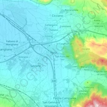
Name: Nola topographic map, elevation, terrain.

Location: Nola, Napoli, Campania, 80035, Italy (40.85709 14.45305 40.98299 14.57436)

Average elevation: 407 ft

Minimum elevation: 79 ft

Maximum elevation: 2,654 ft

Gear up for your next adventure:

🪶Thermal Camp Blanket - Extra warmth for cold nights
Backpacking Tents - Weight-optimized shelters for multi-day topographic surveys
🥤Water Filter Bottle - All‑in‑one filter bottle for safe hydration
🪶LED Camping Lantern - Bright lantern for camp lighting
🥩Freeze-Dried Meals - Nutritious and lightweight food for remote expeditions

As an Amazon Associate, this site earns from qualifying purchases at no extra cost to you.