Geolocate

Straden topographic map

Click on the map to display elevation.

About this map

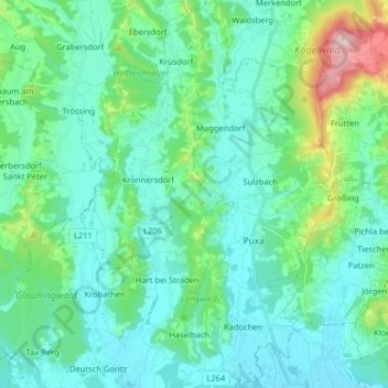
Name: Straden topographic map, elevation, terrain.

Location: Straden, Bezirk Südoststeiermark, Styria, 8345, Austria (46.74626 15.82691 46.85637 15.92825)

Average elevation: 968 ft

Minimum elevation: 745 ft

Maximum elevation: 1,988 ft

Other topographic maps

Click on a map to view its topography, its elevation and its terrain.

Unterlaasen

Austria > Styria > Bezirk Südoststeiermark > Patzen

Average elevation: 958 ft

Wieden

Austria > Styria > Bezirk Südoststeiermark > Feldbach > Wetzelsdorf

Average elevation: 1,161 ft

Pölten

Austria > Styria > Bezirk Südoststeiermark

Average elevation: 830 ft

Gear up for your next adventure:

🧭Orienteering Set - Complete compass and map reading kit
🗺️Topographic Maps - Detailed topo maps for hiking, exploring and outdoor navigation
🪶Compact Camp Shovel - Folding shovel for campsite tasks
🧯Portable Fire Pit - Compact fire pit for camping spots
🧤Hiking Gloves - Protective gloves for rugged trails

As an Amazon Associate, this site earns from qualifying purchases at no extra cost to you.