
Make a donation
Gear up for your next adventure:
As an Amazon Associate, this site earns from qualifying purchases at no extra cost to you.
Kataragama topographic map
Click on the map to display elevation.
Make a donation
Gear up for your next adventure:
As an Amazon Associate, this site earns from qualifying purchases at no extra cost to you.
About this map
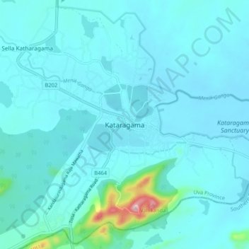
Name: Kataragama topographic map, elevation, terrain.
Location: Kataragama, Monaragala District, Uva Province, 91400, Sri Lanka (6.37356 81.29244 6.45356 81.37244)
Average elevation: 220 ft
Minimum elevation: 112 ft
Maximum elevation: 1,325 ft
Make a donation
Gear up for your next adventure:
As an Amazon Associate, this site earns from qualifying purchases at no extra cost to you.
Other topographic maps
Click on a map to view its topography, its elevation and its terrain.
Yala National Park
The Yala area is mostly composed of metamorphic rock belonging to the Precambrian era and classified into two series, Vijayan series and Highland series. Reddish brown soil and low humic grey soil are prominent among six soil types. Yala is situated in the lowest peneplain of Sri Lanka, which extends from…
Average elevation: 213 ft