
Thank you for supporting this site ❤️
Make a donation
Make a donation
Gear up for your next adventure:
As an Amazon Associate, this site earns from qualifying purchases at no extra cost to you.
Azzaba topographic map
Click on the map to display elevation.
Thank you for supporting this site ❤️
Make a donation
Make a donation
Gear up for your next adventure:
As an Amazon Associate, this site earns from qualifying purchases at no extra cost to you.
About this map
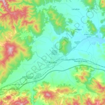
Name: Azzaba topographic map, elevation, terrain.
Location: Azzaba, Azzaba District, Skikda, Algeria (36.67740 6.99444 36.82875 7.18840)
Average elevation: 571 ft
Minimum elevation: 144 ft
Maximum elevation: 1,722 ft
Thank you for supporting this site ❤️
Make a donation
Make a donation
Gear up for your next adventure:
As an Amazon Associate, this site earns from qualifying purchases at no extra cost to you.
Other topographic maps
Click on a map to view its topography, its elevation and its terrain.
Menzel El Abtal
Algeria > Skikda > Azzaba District > Azzaba > Menzel El Abtal
Average elevation: 341 ft