
Make a donation
Gear up for your next adventure:
As an Amazon Associate, this site earns from qualifying purchases at no extra cost to you.
Saka topographic map
Click on the map to display elevation.
Make a donation
Gear up for your next adventure:
As an Amazon Associate, this site earns from qualifying purchases at no extra cost to you.
About this map
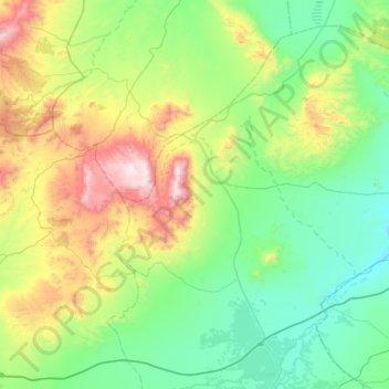
Name: Saka topographic map, elevation, terrain.
Average elevation: 2,116 ft
Minimum elevation: 833 ft
Maximum elevation: 5,984 ft
Make a donation
Gear up for your next adventure:
As an Amazon Associate, this site earns from qualifying purchases at no extra cost to you.
Other topographic maps
Click on a map to view its topography, its elevation and its terrain.
Middle Atlas
Maroc > Cercle de Guercif > Barkine
La combinaison de la température et de la pluviométrie est de nature à créer des conditions favorables à des ceintures de végétation : ainsi, on verra se succéder en fonction de l'altitude et des expositions, des forêts de caroubier ou kharroubier, chênes verts, et cèdres (cedrus atlantica),…
Average elevation: 9,836 ft