
Thank you for supporting this site ❤️
Make a donation
Make a donation
Gear up for your next adventure:
As an Amazon Associate, this site earns from qualifying purchases at no extra cost to you.
Huillcapata topographic map
Click on the map to display elevation.
Thank you for supporting this site ❤️
Make a donation
Make a donation
Gear up for your next adventure:
As an Amazon Associate, this site earns from qualifying purchases at no extra cost to you.
About this map
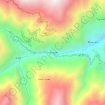
Name: Huillcapata topographic map, elevation, terrain.
Location: Huillcapata, Curahuasi, Abancay, Apurímac, Perú (-13.66143 -72.61265 -13.62143 -72.57265)
Average elevation: 10,850 ft
Minimum elevation: 8,891 ft
Maximum elevation: 13,077 ft
Thank you for supporting this site ❤️
Make a donation
Make a donation
Gear up for your next adventure:
As an Amazon Associate, this site earns from qualifying purchases at no extra cost to you.