Geolocate

Paje topographic map

Click on the map to display elevation.

About this map

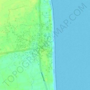
Name: Paje topographic map, elevation, terrain.

Location: Paje, Kusini, Zanzibar South & Central, Zanzibar, Tanzania (-6.27382 39.52544 -6.25732 39.53675)

Average elevation: 20 ft

Minimum elevation: -3 ft

Maximum elevation: 49 ft

Other topographic maps

Click on a map to view its topography, its elevation and its terrain.

Unguja

Tanzania > Zanzibar South & Central

Average elevation: 20 ft

Dunga

Tanzania > Zanzibar South & Central

Average elevation: 102 ft

Makunduchi

Tanzania > Zanzibar South & Central

Average elevation: 56 ft

Makunduchi

Tanzania > Zanzibar South & Central

Average elevation: 56 ft

Gear up for your next adventure:

🛰️Satellite Messengers - Emergency SOS and two-way messaging for off-grid adventures
🏔️Mountain Trail Maps - High‑detail maps for popular peaks
🧼Biodegradable Camping Soap - Eco‑friendly soap for outdoor hygiene
🏫Relief Map Kits - Hands-on tools for teaching landforms and elevation
🌐World Map Poster - Decorative world maps with topographic info

As an Amazon Associate, this site earns from qualifying purchases at no extra cost to you.