
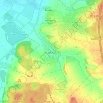
Jedelhausen topographic map
Interactive map
Click on the map to display elevation.
About this map
Name: Jedelhausen topographic map, elevation, terrain.
Location: Jedelhausen, Neu-Ulm, Landkreis Neu-Ulm, Bayern, Deutschland (48.35048 10.05839 48.35756 10.06550)
Average elevation: 1,640 ft
Minimum elevation: 1,555 ft
Maximum elevation: 1,736 ft
Other topographic maps
Click on a map to view its topography, its elevation and its terrain.
Schloss
Deutschland > Bayern > Landkreis Neu-Ulm > Neu-Ulm > Holzschwang
Holzschwang liegt am östlichen Rande des Höhenzuges zwischen Iller und Roth auf einer Höhe zwischen 490 und 520 m ü. NN und bildet den süd-östlichst gelegenen Ortsteil Neu-Ulms. Die Entfernung zum Stadtzentrum beträgt rund 10 km über die unmittelbar am westlichen Ortsrand entlang verlaufende…
Average elevation: 1,650 ft