
Pantops topographic map
Click on the map to display elevation.
About this map
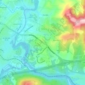
Name: Pantops topographic map, elevation, terrain.
Location: Pantops, Albemarle County, Virginia, 22909, United States (38.01022 -78.46382 38.05022 -78.42382)
Average elevation: 482 ft
Minimum elevation: 289 ft
Maximum elevation: 997 ft
Albemarle County trails, hiking, mountain biking, running and outdoor activities
Other topographic maps
Click on a map to view its topography, its elevation and its terrain.
Darden Towe Park
United States > Virginia > Albemarle County > Charlottesville > Franklin
Average elevation: 423 ft
Beaver Creek Park
United States > Virginia > Albemarle County > Charlottesville > Wickham Pond
Average elevation: 607 ft